New app launched to give more accurate picture of Storm Arwen impacts
2 February 2022
Forest Research has launched a new citizen science app combining England and Scotland windblow data to increase the knowledge of the full impact of Storm Arwen.
UPDATE - 2nd February 2022
Troubleshooting for windblow app and impact of Storms Corrie and Malik
We have received a few reports that some members had experienced problems using the wind blow app. In discussion with Forest Research we identified potential places where the app may have issues:
- In order for the map to draw it needs a strong data signal, if working remotely with poor connection this can cause the map to freeze and not reload. This is because when the map is moved it redraws the whole country with you at the centre, not just the section you can see. This is out of the control of FR as the app is a platform created by ESRI.
- If the device loses all data connection (is effectively off line) the map will not refresh, however it will load to the last place it had signal which is unlikely to the current location, effectively making it look like the system has crashed.
- The form used to collect data such as species will work when the device is off line and store the information to send once it has data connection again. This again makes the app appear to have issues as the map will not be working but the form will.
- The base of the app is built by ESRI and is intended for newer devices, if you have a older phone or tablet it may struggle to load the app correctly, if this is the case use the web portal which accepts the same information.
- The intention of the app was to validate areas and collect areas missed. If you are drawing new complex areas which means moving the map a lot that can cause issues especially on a phone as the map redraws each time you move it.
Many of the issues can be overcome by validating areas on the webpage which can be done from a desk rather than in the woods. If you are experiencing issues with either the app or web page please inform Richard.hunter@confor.org.uk so that they can be tracked and dealt with. This will also help us build a better system in preparation for the next time the app is needed.
The Storms Corrie and Malik which hit over the 29th and 30th Jan added insult to injury by increasing the amount of damage by Storm Arwen, although not on the same scale it has increased the amount of wind blow to be dealt with. The app created to record Arwen’s damage is still open to the 31st March, however the maps visible will not have any of Storms Corrie or Malik damaged shown. If you do draw on areas of new windblow please ensure you tick unknown/other on the Storm Event question and add a note in the comments box. This will allow FR to separate the data when it is under analysis. There are no plans as yet to add Corrie's and Malik's damage to the maps as there are issues with the Sentinel 1b satellite. We will update you further regarding changes to map as it happens; if needed we can also add another box to the Storm Event to allow easy validation of these areas.
-----------------------------------------------------------------------------
UPDATE - 24 January 2022
Guidance note, originally created by Forest Research but amended for Confor members, outlining how to validate the mapping of the windblow from the analysis of the satellite imagery. Download here.
-----------------------------------------------------------------------------
December 2021
The app is easy to use and allows anyone to validate and improve the information available.
Confor members are urged to sign up and give the feedback requested, which can include verification of windblow identified using satellite imagery. The app also offers the option to state if it is the correct area, whether new or old, what extra felling area will be required up to the windfirm edge and what species are involved.
Richard Hunter, Confor's Technical and Industry Support Manager, said: "This is an opportunity to identify some windblown areas that might have been missed, and to enhance what we know already. This will be very important as we try to manage the situation and maintain as stable a market for timber crops as possible."
The app will remain open until 23 January and the information collected will be turned into a report to support the industry.
The app launched on Friday 17th December at 4pm and by Monday 20th December at 9am, already had more than 100 hectares validated, much of that removing false positives produced by satellite imagery. New information is fed back into the algorithm that reads the satellite data and turns it into a shape file. The system learns and therefore the next imagery reading is more accurate - so the more area validated, the more accurate it becomes.
Mr Hunter thanked Confor members who provided valuable information through a windblow questionnaire sent out recently, adding: "This has now been superseded by the new app - produced by Forest Research, with the support of Scottish Forestry, Forestry Commission and Confor. We encourage members to engage fully with this app."
Mr Hunter also reminded members to work with clients to understand that tackling windblow is potentially dangerous work - and should be mechanised wherever possible, by competent and experienced contractors.
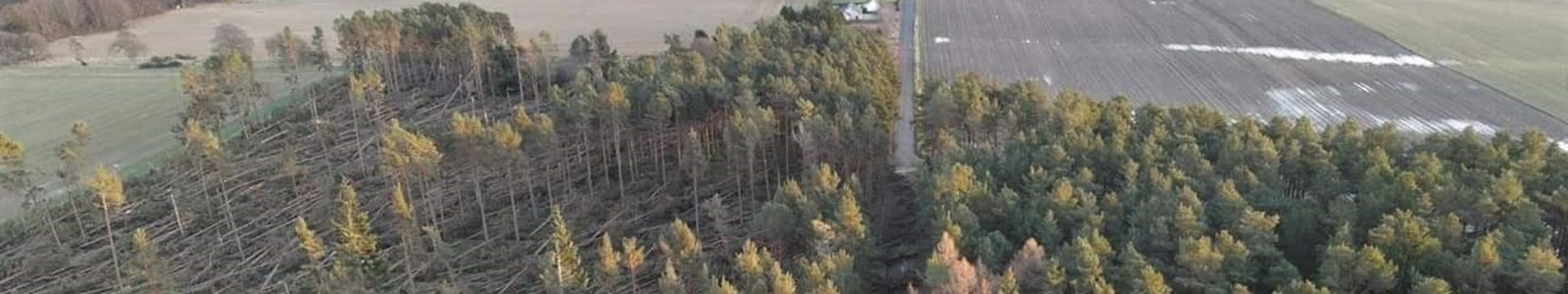
This is the latest collaborative effort between Confor and the public forest bodies in response to Storm Arwen, which caused intensive damage to Scotland’s woodlands - especially down the east coast, across the Borders and East Lothian, stretching into Galloway. Another swathe of damage runs through Aberdeenshire, Angus and into Perthshire. There was also significant damage in northern England.
Scottish Government Environment Minister Màiri McAllan said: “Storm Arwen provided a salutary lesson of the power of nature and the challenge of climate change. Our people suffered and so, too, did our natural environment.
“The impact is evident in the distressing images of flattened forests and woodlands which will take decades, if not centuries to recover from. Their loss reminds us of the significant role trees play in our lives, communities, economy and wellbeing.
“Behind this is a monumental clear-up operation which is being undertaken by large and small woodland owners. Whilst this is being carried out, the message to the public is not to enter into affected forests until they are made safe.
“Forestry might be a long term business, but getting to grips with managing the windblown timber has already begun. As more accurate information becomes available, Scotland’s forest industry will be taking decisions on handling the extra volumes of timber that needs to be harvested.
”Through Scottish Forestry, advice, information and assistance is being made available to woodland owners and the forestry sector to help manage the aftermath of Storm Arwen.”
Andy Leitch, Deputy Chief Executive of Confor, said: "With new information emerging every day about the impact of Storm Arwen - from satellite data, localised aerial surveys and on-ground observation - it is vital that the industry and the public forestry bodies work together as closely as possible.
"The most effective way to ensure windblown trees are removed safely and quickly is to share information, identify opportunities for joint approaches - and deploy resources where they are most needed.
“The clean-up after the storm - and the work needed to remove the windblown timber, make safe the remaining trees and get the timber to wood processors - will take time and effort. However, Confor is fully committed to working in partnership with the public forestry bodies to make that happen in a speedy and efficient manner."
Scottish Forestry, Confor and FLS will continue to work closely at both national and levels, taking into account the different timber markets.
Scottish Forestry has already deployed its staffing resource to the areas most affected, anticipating that woodland owners in the areas affected will require advice.
Action to fast track and simplify the paperwork around Felling Permissions and Forest Management Plans has been undertaken to help woodland managers tackle trees that were affected by windblow.
FLS began discussions with its timber customers straight after Storm Arwen hit to determine market availability, volume requirements and species demand. The agency, which manages the national forests, is also compiling more detailed information on areas, volumes, species and damage types in order to prioritise areas for harvesting and sale.
Most of the trees that have been flattened will be removed over the next year and sent to wood processors across Scotland. In time, the forests will be replanted.